Where was it?
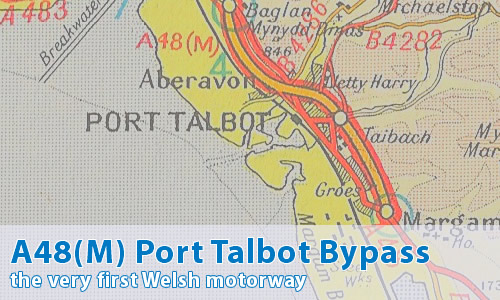
Port Talbot, Glamorgan.
It's now part of the M4 between junctions 39 and 41.
Can you show me that on a map?
What makes this a pathetic motorway?
It's really cheating for it to be in here, isn't it..
Why?
Well, it might have been in the "former" section, but it's still a motorway...
So why is it here?
Simply because this bit of A48(M) doesn't exist - it's been eaten up by the M4!
Hmm...
I know, I know - but this is my website, OK?
The A48(M) is a "former motorway", hence is pathetic by definition. The A48(M) is also the oldest motorway in Wales, being opened a few months before the Newport Bypass section of M4.
By the way, if you want to meet its cousins, here's the A48(M) Morriston By-pass and the modern A48(M).
So when did it become part of the M4?
Well, I can't answer that for definite, but I have a 1975 map showing this section numbered as "M4", so I'll go with before then. The map above is from 1972, so sometime in that period, eh?
Have you got a better map?
Yes, there's this Ordnance Survey sheet...
Can I comment on this motorway?
Of course! Contact me and I'll put them here!
Have any other visitors commented?
SABRE's Crobzub gives us a few extra reasons for the inclusion:
Because its renumbering is about the only reason why it's in Pathetic Motorways, I thought I should add some more reasons.
1. Only two lanes each way, when three lanes are needed during rush hour.
2. No complete hard shoulders when it was A48(M). (I think...)
3. 50mph speed limit (some of it)
4. Two Gatso cameras.
5. Short and narrow slip roads, including the main junction for Port Talbot from the Swansea direction.
6. It used to end at a roundabout, then sending the traffic along an A-road until not that long ago.
Maurice Frank replies:
Hmmm? Admitting I've not passed this way at rush hours, I certainly have at other times in midsummer. In the modern era since the Briton Ferry bridge opened. West of junction 41 it's the overcapacity that is amazing to behold. There are 2 motorways running parallel alongside each other. One is the main M4 diverted over the said bridge, the other is the original motorway ending at the Briton Ferry roundabout, part of the original A48(M). Because this is no longer the main motorway, it now seems hardly used, to my sight outside rush hours. There is over a mile of it: fancy building that duplication. The South Wales main railway line runs between them and you can stand on Baglan station with a full motorway on each side of you. All this land use is in one of those squashed bits of Welsh coast where there is hardly room to squeeze a stem shaped town in between the sea and the mountains.
The original was labelled "temporary motorway terminus" by the AA for at least 16 years until the M4 was completed, and it was retained as a permanent junction after all. It must have earned its place in the local traffic patterns? That's why the junction numbers don't quite work. Now of course it's a spur section, that could quite logically go back to the A48(M) name. Can we have it listed as a hidden motorway, on grounds that it was renumbered from A48(M) to part of the M4 which reason was later reversed when the M4's main course was diverted away from it again?