Where was it?
The clues are in the name...
Don't be like that!
OK, then. It's the bypass for Chatham, Gillingham and Rochester - the Medway Towns, see?
Show me a map, then.
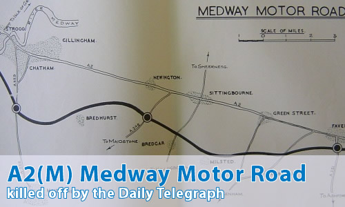
OK, seeing as you asked so nicely...
Hang on a minute! That's the M2 - this should be all about the A2(M)!
You're good, you are. Paying attention, too.
Oh, don't be like that! I'm guessing that there's a story behind this.
Indeed there is, and it's a strange one at that.
Originally, the Medway Towns Bypass was allocated the A2(M) number, as a bypass along an ordinary all-purpose road, similar to the A1(M). The M2 was originally allocated to a mysterious "Future Channel Ports Motorway". No more details of the mysterious original M2 have come to light, with some people speculating that the modern-day M20 is similar to that route. After all, there's not very many ways that you can sensibly build a motorway through Kent.
OK, I'm with you so far - now why was it changed?
This is going to sound really, really stupid, but it's the truth. Perhaps it's a sign of 1950s Britain, but it's certainly something that would never happen today.
The Daily Telegraph decided it.
What??? Did I hear you correctly? Are you sure?
I said you'd never believe me. It's true.
The Telegraph included an article and an editorial in their edition dated 15th December 1959. In this article, they described the proposed A2(M) Medway Motorway throughout as "M2".
So, the Ministry responded three days later in some minutes recorded at the National Archives:
Although M2 has been reserved for a possible Channel Ports Motorway I understand that it is now unlikely that this road will ever materialise. The nearest approach to it will be the Medway Motorway which, according to the principles set out above should be numbered A2(M). If this is so, however, we may never have an M2 unless it should be the Brighton Radial, but as Mr. Adams points out in minute 13 M2 should lie close to the Thames. The Medway Motorway is 26 miles long, shorter than the Darlington Bypass and Durham Motorway which I have suggested should be A1(M). My recommendation would be nevertheless that the Medway Motorway should be M2 as you will see from Doc.26 that the Daily Telegraph assumes that it will be.
Can I comment on this motorway?
Of course! Contact me and I'll put them here!
Have any other visitors commented?
Ritchie Swann has some questions [July 08]:
I have two questions:
1) There seems endless speculation that the M2 was designed to be extended at both ends. The A2 west of Three Crutches is now a motorway in all but name, while the kink right before Brenley Corner at the other end seems to invite it should have gone straight on at some point. Do we have any concrete evidence of this anywhere or is it wishful thinking?
2) If this was supposed to be numbered A2(M), what was the old A2 through the Medway towns, Sittingbourne and Faversham going to become? A299? A278? Or something else?
Tim Lidbetter remarks [July 08]:
I always thought the M2 was a bit pathetic anyway, isolated in North Kent with no direct connection to any other motorway and, until the recent upgrade, only two lanes each way with some pretty substandard junctions.
Tony Frost says [July 08]:
Living close to the M2 (or is it A2(M)?), I have been quite interested in the history of this road. What has always struck me is that it is wholly out of keeping with its bigger brothers - all the Mx motorways - in terms of length and scale (although there are some pretty substantial bridges and viaducts along its length).
It is far more in keeping with its cousin the A1(M) Doncaster Bypass. It is the same length, the same age, the same width, a similar number of junctions, and takes a major trunk road around a major conurbation - and therefore your article does not surprise me at all.
I am surprised it has held onto the M2 classification over the years and not reverted to Ax classification. With the recent major investment in the last 10 years that now seems highly unlikely.