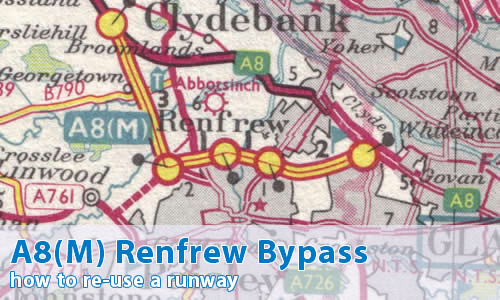
Where was this one?
Around the old county town of Renfrew, about six miles to the west of Glasgow.
Can you show me that on a map?
What makes this a pathetic motorway?
As is usual with these things, not a lot at first sight. Today it's now just a fairly anonymous part of the M8 that thousands of people use daily without thinking about it, but as is usual, it's a little more interesting than that.
When it opened in 1968, it was the first motorway section to the west of Glasgow, bypassing the congested A8 through Renfrew, as well as acting as a northern bypass for Paisley, Scotland's largest town. and acting as the eastern approach road for the new Abbotsinch Airport, now Glasgow Airport. For nearly ten years it was separated from the rest of Scotland's motorway network until the M8 was extended westwards to meet it, whilst on the western side the first section of the Bishopton Bypass (including the M898) was opened in 1970.
Looking at the road itself there are a couple of interesting features. The first is that there is a completely straight section between what is now M8 junctions 26 and 27. On this section, the motorway uses the line of the runway of the former Renfrew Airport, which closed in 1966 in favour of the current site of Glasgow Airport and was pretty much immediately ripped up in favour of the motorway.
On top of that, some of the most impressive engineering on the Scottish network happened on this fairly anonymous bit of motorway, including the enormous (and seemingly constantly under repair) White Cart Viaduct.
That sounds all a bit, well, good.
It is good! But there are a couple of reasons too why it appears here.
Firstly, the original western terminus was at a junction with the A8, long since closed - though in true PM style, no-one is quite sure exactly when. The junction certainly survived the opening of Stage I of the Bishopton Bypass in 1970; though the good folk at Glasgow's Motorways have uncovered that the original junction layout was pretty much a simple T-junction though the carriageways did flare out to meet the M8. This was altered very early on to a more familiar layout of a loop in the northeast corner, and it is believed that this layout of the junction survived until around 1975, when the Stage II of the Bishopton Bypass (the part of M8 west of the M898) opened.
Plenty of evidence of the junction can be seen on the ground today, as long as you know where to look!
That's better!
Glad you approve!
Of course the other reason for it being here is the number: A8(M) doesn't exist any more. But even here there's a story to tell...
What on earth are you on about now?
OK, there is debate about whether the A8(M) number itself ever existed!
It's certain that the number appears on early mapping, such as on this map kindly provided by Jonathan Cossham. However, research carried out by the staff at Glasgow's Motorways would appear to indicate that the number was never used "on the ground", and so never actually appeared on signage. They have turned up the original opening brochure of the Renfrew Bypass, which clearly says "M8 Renfrew Bypass" on the cover, as well as other brochures published for the public, all of which unerringly use the M8 number.
Case closed. So the A8(M) number is just a mapping error.
Err, no.
There is actually a huge wealth of information in other Government documentation that refers to the A8(M) number, though the pattern is confusing and inconsistent, but what is clear is that references to A8(M) continue for a couple of years after the opening of the Renfrew Bypass; and indeed there are some examples where A8(M) is also used to refer to the Bishopton Bypass to the west after the Renfrew Bypass opened.
It seems that the A8(M) number was used to refer to the entirety of what is now the M8 whilst motorway numbering in Scotland was still in a state of flux. Before long, the Edinburgh to Glasgow Motorway (i.e the M8 east of Glasgow) is referred to by the M8 number; whilst the A8(M) number was used only to refer to the motorway to the west of Glasgow (the Glasgow to Greenock Motorway), before finally only referring to the Renfrew Bypass.
The whole mess can be summarised as:
The motorway to the west of Glasgow was initially known as the A8(M) during the planning stages and was consistently described as a different motorway to that to the east of Glasgow, but the Renfrew Bypass opening booklet and other contemporary documentation written for the public consistently uses the term M8, so the balance of probability is that the number of the Renfrew Bypass changed at the last minute, and opened with the M8 number, but official references to the A8(M) number continue for a year or so after opening.
This theory fits in exactly with what happened a few years earlier to the A4(M)/M4 Maidenhead Bypass, roughly contemporarily with the A40(M)/M40 High Wycombe and Beaconsfield Bypasses and later with the A48(M)/M4 Morriston Bypass.
But it is just a theory, but it seems to fit the facts as they are currently known...
Can I see some photographs now?
Can I comment on this motorway?
Of course! Contact me and I'll put them here!
Have any other visitors commented?
Not yet, they haven't.