Where's this then?
The M25. Or at least some of it.
What do you mean, the M25?
What do you think I mean?
Don't be awkward - I ask the questions around here!
OK, you do. Large parts of what was to be the M16 has ended up being subsumed into today's M25. Indeed, about 30 miles of M25 were originally part of M16; with another 4 miles that may well have been, but no firm evidence has yet come to life.
Mind you, only 59 miles of the M25 were planned all the way through as M25...
Right. So some of the M25 was supposed to be M16?
You've got it! In fact, you can see a map of the first section here, and thanks to Chris Marshall, you can also see a map of the entire eastern section, and compare M16 with M25.
So, tell me more about it then.
OK. Yet again we'll be talking about London Ringways, and the plans for a network of motorways around (or through!) London. You'll find more details in the Ringways for Beginners feature.
The outer orbital motorway for London was Ringway 4. This was planned to be a combination of M25 South Orbital Motorway, which went from the M20, along today's M26, round the south and west of London to end at Hunton Bridge, present J19a where it would end on the A41(M) motorway. The rest of Ringway 4 to the north would have been built as an all-purpose road, or in layman's terms, an A road.
The next orbital in would have been Ringway 3. This consisted of the M16 from Dartford heading around the present M25 to junction 23 where it would have diverged to the southwest, meeting the M1 between junctions 4 and 5, heading round to M4 J3, then across to M3 J1. It would then have moved around the south of London to Addington, and back to Dartford. However, there is no evidence that the M16 number would have been used for the entirety of Ringway 3. For quite some time it was known that M16 would have been used between the A1(M) and the Dartford crossing, around the north and east of London. It was supposed that the section between A1(M) and M1 would probably have held the M16 number, but it couldn't have gone west of the M1 as the number would have been incorrectly used. Or could it?
Well, the first hints that the M16 number may have been used west of the M1 were found at the National Archives, when a file listed as "Highway projects: Ringway 3 (M16); Yeading to South Mimms" (file number MT 106/118 if you really want to know...) came to light. Whilst being a very interesting file showing the proposed routing of Ringway 3 in the northwest of London, it had one iddy-biddy problem with it, as far as the M16 was concerned.
What was that then?
Well, the only place that the M16 number actually occurred was in the file title - nowhere in the documents inside the folder!
Oops!
Yeah, that's about right! So near, and yet so far.
The trail of the M16 seemed to end there in a really annoying place. Was it a lazy or incorrect file title, or was the title correct and it was just happenstance that none of the documents that used "M16" had been preserved? The trail went cold at that point.
Then suddenly, a year or so later, something turned up. In a Ministry document dated April 1973, there included the phrase "M16 Uxbridge Road (A4020) - M1" as being listed within the Motorway Preparation Pool. Suddenly the M16 number could be traced all the way around to Hayes, just north of the M4. Would it have continued? Probably, though it can't be said with any certainty. Perhaps something else will turn up one day!
Did any of it actually open as M16?
Well, the first section of both M16 and M25 (between present J17 and J19a) were both opened as all-purpose roads despite being planned and built as motorway, and were intended to be renumbered later when more of the routes were opened. The M16's "alter ego" was A1178.
Then came 1975.
What happened in 1975?
The DoT announced that there would be one outer orbital motorway around London: the M25. The planned route of M16 from junction 23 to Dartford was given the go-ahead, but several important changes were made to the plan. Firstly, the M26 was born as the M25 was turned north instead of east, to head towards Dartford, and the mess that is the present day junction 5 was born. The new southern approach roads to Dartford under construction at the time were hurriedly redesigned to take the motorway into account, and a whole new section connecting the present J3 to J5 was born.
Sections of M16 and M25 to the north had opened earlier than this, but they had been opened without motorway restrictions, so there was a renumbering to occur there anyway.
The biggest change occurred in the Watford area. Suddenly, there was a gap where the two rings were never meant to meet, but they suddenly had to! What was the solution? The current "bump" around Watford was shoehorned into the plans, including a new junction to take the motorway away from Hunton Bridge, and a section of A6 was stolen too, which was upgraded into a part of the M25. The western end of the M16 is really obvious, though, as just east of the A1(M), the carriageways split to allow for the never-built main route to carry on towards Bushey, whilst the M25 curves off to the north.
Can I see some photographs?
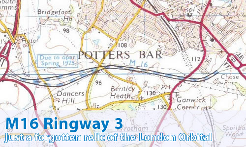
Can you show me where it was supposed to be on a map?
Can I comment on this motorway?
Of course! Contact me and I'll put them here!
Have any other visitors commented?
Mark Whittingham starts:
I clearly remember the M16 being built, in the mid-1970's. It was also labelled 'The South Mimms Improvement'. My dad always got frustrated because this road was only about 3-miles long. At least it cut-out Potters Bar town centre from our route....