Where was it?
Morriston, Glamorgan.
It's now part of the M4 between junctions 44 and 46.
Can you show me that on a map?
What makes this a pathetic motorway?
It's another part of A48(M) that's been swallowed by M4.
Is that it?
Yep, that's it. This bit of A48(M) only survived as such for a couple of years at most - by 1975 it had become part of the M4.
Anything else?
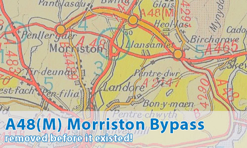
Yes, I've also come across this Ordnance Survey One-Inch sheet showing the Morriston Bypass under construction, clearly labelled as A48(M).
Can I comment on this motorway?
Of course! Contact me and I'll put them here!
Have any other visitors commented?
Simon Davies tells me a few things!
I like the work on the A48(M), but I have one minor piece of (potentially) bad news. As far as I can remember the Morriston bypass has only ever been numbered M4. Admittedly I was only 3 when it opened, but I can recall the A48(M) around Port Talbot being there whilst the Morriston section was known as the M4.
The UK Motorway Archive suggests that when first mooted the road was planned as an A road and only later was the decision taken to build it to motorway standards as part of the M4. This may explain why some atlases have labelled it as A48(M) but I don't think it has ever been open to traffic with that number. I can still recall the route confirmatory sign east of junction 46, which was huge. It started with M4 at the top, then ran through London 191, Newport, Cardiff, Port Talbot and Neath with mileages to each of these as well. That sign is long gone - I think it disappeared at about the time the M4 was eventually finished so you could actually drive most of the 191 miles to London on the M4.
I cannot vouch for what the road was numbered as when it opened, but it opened when I was 3 years old and I only ever recall seeing M4 signs on there. I can say with absolute certainty that it was numbered M4 long before anyone put so much as a spade in the ground to build the Pontardulais bypass section as I remember watching that being built - it's what got me into roads in the first place.
My 1976 edition Bartholomew shows the adjacent stretch of M4 to Pyle under construction with the Port Talbot bypass marked as M4. My memory is a little hazy but I remember my Dad telling me that it had been announced that the M4 would be extended west from Newport to link up with the Port Talbot and Morriston motorways and the Port Talbot bypass would be renumbered M4.
The Pyle bypass opened in 1977, as did the Pontardulais bypass.Unfortunately I don't recall whether the signs were changed before the Pyle bypass opened. I think they were but I don't know how far in advance that happened.
One final word on Morriston and Port Talbot - both bypasses deserve to be in Pathetic Motorways - they should both be dual 3 lane, as should the new Briton Ferry Bridge section which links the two.
Mark Dillon comments:
Some more proof of the original numbering of this road perhaps?
I recently unearthed a 1972 Esso GB road atlas in my gran's attic and lo and behold the then under-construction Morriston bypass is quite clearly marked as A48(M).
Perhaps soon after opening it was changed to M4 but I believe it was originally intended to be A48(M).