Where is it?
East of Cardiff, in traditional Monmouthshire.
In modern terms, it now lies within the County Borough of Newport (Casnewydd) and the City and County Borough of Cardiff.
It meets the M4 at junction 29.
Can you show me that on a map?
What makes this a pathetic motorway?
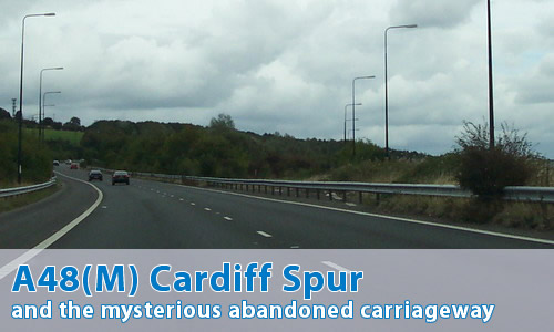
It's yet another of those tiny spurs that take traffic from a major motorway into an urban area: in this case from the M4 into Cardiff.
Oh right.
Not only that, but it's a "left over" bit of M4. The motorway's original main route in the area was down the current A48(M), but the M4 was taken west from the current J29, leaving this bit left over.
The abandoned former carriageway can be seen in this aerial photograph. Disappointingly, there's no way of getting there and having a proper look at what's left over, unlike the A18(M).
Hang on a minute - I've seen some old maps!
Yes...
This isn't the A48(M)!
Oh yes it is! The A48(M) has a very chequered history. This is the modern A48(M). What you're thinking of is the former A48(M), now part of the M4. Both the Port Talbot Bypass and the Morriston Bypass had this number until it was all joined up. This was pretty much standard practice in the early days of motorway building.
Other examples would be the A20(M) Maidstone By-pass (now part of the M20) and the A4(M) Maidenhead By-pass (now part of the M4).
Can I see some photographs?
Can I comment on this motorway?
Of course! Contact me and I'll put them here!
Have any other visitors commented?
Maurice Frank comments:
At the 'end' of the A48(M) you pass a trailing junction with no access option for the motorway. You pass an arbitrary 'end of motorway' sign, then are forced to continue for at least another mile along what still physically is a motorway! That's a patheticity unequalled anywhere else! The A48 is motorway standard for 4 miles into Cardiff beyond the A48(M), and is all called 'the motorway' by locals, but only the first section off the M4 is forced to have an (M) number! The whole length should be designated A48(M) and it would be a good spur motorway 6 miles long.
Simon Davies throws up an issue:
Well done for some great pictures! However, I'm not sure that your information is 100% correct. Sorry! I only know because I posted something on SABRE to the same effect and was corrected by someone.
Although the A48(M) was built before the section of the M4 between J29 and J32, work started on the construction of the Cardiff Bypass section on the day the A48(M) was opened. This would suggest that junction 29 was planned that way before the A48(M) was built (given the time it takes a road to get through the planning process). My personal recollection is that the overbridge carrying the eastbound A48(M) over the unbuilt M4 was there when that section of the road opened.
However, in recent times I have also noted the apparently abandoned carriageway and assumed that my recollection was wrong. I posted to this effect on SABRE. Another Sabristi pointed out that the abandoned carriageway is actually much newer than the remainder of the junction - it was built as a temporary diversion for traffic during major maintenance work, and left in place when complete.
My response to Simon's comments: The abandoned carriageway runs quite clearly to the eastbound carriageway of the A48(M), and the barriers cut across it. It's entirely parallel with the A48(M)'s westbound carriageway.
For which carriageway was it a temporary replacement? If it was for westbound carriageway, then why does it quite clearly "exit" onto the eastbound carriageway, not as a "right-hand" entry onto the westbound? If it was for the eastbound carriageway, then what happened to its traffic (and indeed that of the westbound M4??) at the eastern end?
Simon's response to that:
I'm not sure I know the answer either.
I don't recall junction 29 ever being anything other than the shape it is today, albeit with the M4 itself not yet open. It seems a curious arrangement - unless there was a complete closure of the west bound offslip for reconstruction, which continued along the westbound A48(M). Then the abandoned carriageway tieing into the east bound A48(M) would make sense as it would make provision for westbound traffic to run in contraflow on the eastbound carriageway.
Maurice Frank came up with:
The first time I ever went on the A48(M), westbound on an excursion bus soon after it opened, I was never aware of its divergence from the M4 (J29-32 not built then) and it seemed like the M4 was coming straight out onto the A48 high speed road at J29A and I wasn't expecting it to happen until it did. I never understood that memory, and why I didn't see the eastbound carriageway curve away from us, until now! Still don't see why the abandoned carriageway was built when the plan to extend the M4 from Newport to Pontardulais had already been made by at least 1974 and J32-35 section also opened 1977. It's not like the M53/M531 fiasco.
So, the question was thrown open to the good people of SABRE, and elicited the following responses:
Ritchie333 came up with:
Here's my thoughts on it.
As my nan lived in South Wales, I've been a regular passenger along this part of the M4 for as long as I can ever remember. But first, some history...
Originally, as we know, the M4 stopped at J28 past the Brynglas tunnels. With the addition of the A48 Eastern Avenue (built in the early 60s?), this meant you could travel from London to Cardiff on completely grade separated dual carriageway, except for the bit of A48 through Castleton. So, plans are made to join up the fast dual GSJ A48 with the M4.
Then, after planning this, some bright spark noticed that adding this extension on the M4 would mean a greater influx of traffic bound for Swansea and Camarthen spilling onto Cardiff's urban roads. Hence, the plan to extend the M4 out around Cardiff, but still provide the link to the A48 for Cardiff traffic. Hence, A48(M).
I don't ever remember J29 not having the sliproads in place, even before the M4 around Cardiff was built. So I have two theories :
1) The unused lane was built before plans for the M4 western extension were confirmed. Maybe the builders at the time didn't know exactly where the A48(M) would split from the M4. Certainly the M4 west of J29 skirts close to urban parks and suburban housing estates, so it might have taken quite a while to get planning permission for the finished confirmed route. So the whole 28 - 29A section got built as dual so that could open to traffic while they got the rest of the route projected. Now I don't ever remember seeing the unused lane before the M4 was completed westbound, but I was only around 6 or 7 when that happened.
2) The unused lane was put in later as a temporary diversion. The most possible explanation I can think of for this is that the bridge carrying A48(M) sliproad over the M4 was in some way unsafe and had to be strengthened. This would have meant all M4 traffic would be diverted via the A48(M) and hence eastbound traffic would go across a gap in what is now the central reservation - only possible if the M4 was totally closed to traffic. I'd have said this was unlikely as closing the M4 entirely (as opposed to just putting a contraflow in) and diverting all the traffic around Cardiff would have resulted in total chaos in the area.
So that's my take on it...
And Tony-M25 added:
My interpretation of the information would be that the whole route had been decided before construction began. The earlier section was built with a lane drop at the correct point, so it is likely that the intersection was in place.
The construction of the later section began within weeks of the first section being opened, so it is highly likely that the intersection at the future J29 had been provided hence the higher contract price for a shorter length costed up to 3 or 4 years earlier.
No answer I'm afraid, just background info. My question to add to this: Is the absence of J31 on the M4 somehow tied into this debate?
But M48-Man countered with:
I have just spoken to someone who was the QS on site for Gwent County Council when the A48(M) was reconstructed 14 years ago. He has confirmed that the abandoned road was constructed as a temporary road and was NOT a previous alignment. The barrier and bund was put in place after the traffic had switched back in order to keep travellers off.
And Simon Davies came back with:
I'm inclined to accept M48 Man's account of things in that the abandoned carriageway was a temporary diversion built more recently than M4 J29-32. I've thought back to the time the road was built and I'm certain that the bridge carrying the eastbound A48(M) over the M4 has always been there.
All in all, a can of worms has been opened! Has anyone out there got any more concrete information about the abandoned carriageway, and why it's there?
David Thomas has a question:
Regarding the missing junction 31 on the M4, this was supposed to serve the A469 Cardiff - Caerphilly road at Thornhill in the northern suburbs of Cardiff. I would love to know why it was never built, as the lack of a junction here puts considerable pressure on traffic heading onto both the M4 and the northbound A470 at Junction 32.
In my mind, this junction is a priority to relieve congestion in North Cardiff. I am not sure if it will ever be built though, as I think that housing developments have been sited near to the original location for the exit.
The other junction on this stretch - J30 was not built when this stretch was originally constructed, and I was amazed when it was built ahead of J31, as it is largely redundant, certainly for traffic entering the eastbound M4, as the Eastern Avenue / A48 (M) runs almost parallel to the M4 here prior to merging with it at J29. To my knowledge this junction was built to serve the new district of Pontprennau and a business park.
If anyone has info on J31, I would love to hear it."
Phil Lord adds a vast amount of information:
Let's hope I can get this correct regarding the A48(M) debate.
In the early 60's there had been a great deal of heat generated in the Cardiff area regarding road construction projects and new visions for the city centre. These projects, some proposed by Colin Buchanan, included the infamous 'Hook' road (abandoned after much debate) linking what should have been the 'missing' junction 31 on the M4 leading to the Docks and through the house that I lived in along the way, the 'Box' distributor road around the commercial centre of the city (a mini-Peripherique style road - ugh), and the Llantrisant expressway to what was to have been a 'new' town based on Llantrisant some 10 miles or so to the northwest of Cardiff.
As part of the package was the now constructed Eastern Avenue leading on from Western Avenue - a road originally built in the 1930's - which terminated oddly at Gabalfa - bypassing the less busy western end of the city to dump its traffic along the more densely packed eastern suburbs.
Construction of Eastern Avenue was commenced in the very late 60's to serve the communities of Llanederyn and Pentwyn to form a bypass to the very congested A48 Trunk Road running through the city centre. Eastern Avenue terminated on the Cardiff to Newport road east of St Mellons on a plain at-grade roundabout.
Interestingly if you drive along Eastern Avenue westwards, as you go under the Gabalfa interchange you will see massive retaining walls set at angles away from the main line of the carriageway. These were constructed to accommodate the slip roads intended to be the start of the Llantrisant expressway. Needless to say the proposed 'new' town was abandoned before the concrete had set. Another bit of 'I didn't really want to know this' information for you - in the construction of the Gabalfa interchange the trolleybus terminus that existed on the site of the flyover had to be foreshortened and several properties demolished to make way for the new trolleybus terminus - the only recorded happening of houses being demolished by a trolleybus.
You must remember that at the time the Severn Bridge had only been in existence for a short period and the M4, as rightly pointed out by your other correspondents, terminated a few miles west of the Brynglas tunnels on the Newport to Cardiff road, the A48, on a plain at-grade roundabout.
Eastern Avenue was opened in about 1970 as I had bought my first car in January 1971 and I couldn't wait to drive the then 'new' road when it was finally opened - a proper dual carriageway with grade separated junctions and, albeit narrow, hard shoulders.
Concurrently with this construction, the M4 west of Cardiff was being built despite the fact that the alignment of the M4 around the north of Cardiff had not even been published and it was, I believe, already decided that Eastern Avenue and Manor Way would have to fulfil the 'missing link' between the M4 eastwards at Coryton and its western terminal at Newport for a number of years, which it so did for about 6 - 7 years. As is the want of these things, inevitably traffic chaos ensued on the day of opening of the eastern section of the M4 but never mind.
Gradually the line of the M4 around the north of Cardiff was decided, circa 1975 (there had and there is still talk of an M4 south of the city). The section west of Newport was now under construction but only as far as Castleton with a link, the A48(M), to join up with the A48 Trunk Road (Eastern Avenue) at St Mellons.
The terminal junction of Eastern Avenue at St Mellons was truncated and diverted to become a contiguous link with the end of the A48(M). Access was provided to the A48 by the construction of an overbridge to take the eastbound traffic over the A48(M) on a slip road to rejoin the at-grade roundabout. The western carriageway was not altered and follows the line it always has - thus the reason why it has a rather short lead-in slip onto the eastbound A48(M)/A48 carriageway.
As to the link of the A48(M) with the M4 proper, I believe that as a matter of expediency the two carriageways had been built contiguously to enable traffic to merge seamlessly until such time as the eastbound slip road overbridge was constructed over the M4 and the A48(M) traffic diverted over it. This was so done in the 1980s sometime before the M4 northern section was finally opened to traffic. The eastbound link carriageway became redundant as shown in your aerial photograph. The other road shown in the photograph joined the eastbound A48(M) to the M4 westbound but was used during the period of the construction works of the M4 northern section only and never used by road traffic. It was hard paved and can still be seen on the ground.
In turning to junction 30, this was built quite some time after the opening of the northern section and was partly funded by private developer money to serve the Pontprennau area. It was also needed to serve the east of the city as traffic in the eastern suburbs and bordering along Eastern Avenue had no opportunity to travel along the M4 westwards other than travelling along Eastern Avenue and Manor Way to rejoin the M4 at Coryton since there was no westbound link between the A48(M) and the M4.
As mentioned above junction 31 was to have been the terminal point of the 'Hook' road. Talk of forming the link to serve the Llanishen and Thornhill areas of the city is made from time to time but a difficulty arises in providing such a link as it would be attractive to large volumes of traffic from the Caerfili area along a very steep and substandard section of Thornhill Road - the Caerphilly Mountain Road which rises at 1 in 5 in places. An alternative route has been looked at by driving a new road tunnel through to Caerfili to link the town more directly with the junction - the cost of such a scheme has caused it to be put on the back burner BUT in may be needed sooner rather than later as the A470 Trunk road at junction 32 is now surcharged and is in need of traffic relief measures, one option being the tunnel scheme.
Just one last point regarding Eastern Avenue raised by one of the contributors, it was never built to motorway standards, the interchanges are too small, the slip roads too short and the hard shoulders insufficiently wide to meet motorway requirements.
Without cross-referencing, the dates of importance for the South Wales corridor (apart from Isambard Brunel of course) would be:
1966 - opening of Severn Bridge (Mk I). M4 incomplete and stops outside London at Maidenhead at about junction 8 and restarts at junction 18 (how many times do I remember that we'd travelled to 'America' in such a short time from Cardiff -huh?- we'd be travelling through the village of Pennsylvania - the original from which the state gets its name, apparently) to then terminate just on the Welsh side at what was junction 23 - hence the very straight run up to Pyllmeyric Roundabout on the A48 west of Chepstow (think it might be now called Racecourse Roundabout - no matter).
When the Brynglas Tunnel was completed a couple of years later (I note on the CBRD site it says 1980!) the M4 then terminated at Tredegar Park Roundabout on the A48 and didn't start up again until you got to the A48(M) section around Port Talbot. (I travelled that section many times taking my father to work in Fishguard when I had a car and he didn't. Blew the engine of my Innocenti-Morris 1100TC chasing a Rover 2000TC along it - no contest!).
In or around 1970/1 Eastern Avenue was completed to take the A48 traffic away from the city centre and the M4 extended to junction 29A after then (about 1974) and the section west of Cardiff to Port Talbot was opened just prior to April 1976 (I started work for Mid Glamorgan CC on that date in the office that was dealing with the side road orders and after construction remedial works etc and the motorway from junction 32 had not long opened). From junction 32 northwards the dualled A470 was opened in around 1974.
At about the same time the alignment around the north of Cardiff was being discussed which at one time was going to be benched so that the weary travellers from London and the far flung reaches of the eastern empire could gaze in wonderment at the Bristol Channel glinting in the distance and the vista of the fine and wondrous capital city of Wales stretching out in between. As ever, the environmentalists got in the way and no doubt fired by the Land Compensation Act (noise being one consideration) the M4 around the north is now stuck in a cutting for most of its way and all you MIGHT see is the chimney of the crematorium. This section was opened to traffic well after 1980.
To try and tie the date on the CBRD site regarding the Brynglas tunnel, works didn't finish on that site 'til about 1980 as the bored tunnel method caused subsidence - allegedly - to two properties above. Despite much remediation works these dwellings were finally pulled down.
Ideally I should like to check all the dates in back copies of the local paper 'The South Wales Echo' but they don't appear to have been put on the web and I don't live close enough to do a manual search.
Kim Berry adds some more:
I can confirm M48 Man's comment about the abandoned carriageway linking the eastbound A48(M) carriageway with the westbound M4.
I was commuting daily to Cardiff from Pontypool during the 80's and distinctly remember this as a temporary diversion while the main sliproad was reconstructed. When construction of this diversion began it seemed like some form of widening project. It led onto the eastbound carriageway where there was a contraflow in operation for several hundred yards. Once the reconstruction was complete, the sliproad was indeed "abandoned" but I guess it's still there for the next reconstruction which must be due soon!
Paul Townsend:
I notice you mention the former eastbound carriageway around what is now M4 J29. This disused half is visible from a higher vehicle (e.g. a coach), and the one thing that is really noticeable is how undulating it is compared to the westbound (still in use) carriageway. Any reason for this? It's almost as though they *knew* that the eastbound carriageway would see only temporary use, and did not need to bother raising it up to much of a standard. Alternatively, as Simon Davies says, it was only a temporary measure since I can never remember travelling along it - the current overbridge was certainly there before work started on the M4 proper west of J29.
In response to Tony-M25, J31 was always intended to be the junction with the A469 Caerphilly Mountain route. It remains unbuilt. (Has the A469 itself been demoted?) I hear it that the M4 from J29 to J32 is due to be upgraded to three lanes each way during 2006-2007, so it's just possible that J31 will appear as part of that upgrade.
In reply to David Thomas: J30 serves a useful purpose in allowing decent access from the east end of Cardiff (where I live) to the westbound M4, which previously required negotiating the A48 and A470 routes through Cardiff itself. For me in Llanrumney, best access to the eastbound M4 remains the original A48 through Castleton to J28.
May I also reply to Maurice Frank regarding the A48 dual carriageway which is a continuation westwards of the A48(M). It wasn't always so. What is now a "trailing junction" (bringing in the westbound A48 from Castleton allowing the A48 to bypass St. Mellons and Rumney) once ran straight through, since that part of the A48 dual carriageway is older than the A48(M). Further on, between the Pentwyn and Llanedeyrn roundabouts, the A48 is laid over the top of an old country lane (Church Road, Llanedeyrn), and it was almost as though the ancient right of way could not be obliterated. Even before the dual carriageway was complete, that part of the road was "opened" ASAP with two-way traffic on the one carriageway initially. The continuing legacy of that ancient right of way is, of course, that it could not become a motorway since that would exclude ancient modes of transport which are still permitted on the A48.
Geoff Hanlan:
Looking at the ariel photograph I can see the grassed over carriageway. It is possible that originally it would have been part of a 'normal' dual carriageway or motorway. This could arise from the fact that the then 'proposed' extension of the M4 westwards from Tredegar Park was announced in late 1968. But at that time the M4 around the north of Cardiff was not in the firm programme and was little more than a dotted line on some maps. By the time construction was started on this length between Tredegar Park and east Cardiff the M4 around the north of Cardiff was in the firm programme but not yet started. Mr James Callaghan I think cut the first sod of earth for the M4 around the north of Cardiff on the very day the Tredegar Park to Cardiff section of the M4 was opened in October 1977.
Incidentally Eastern Avenue was built between March 1968 and opened on mid November 1971.