Where is it?
Salford, Lancashire - although it's not obvious...
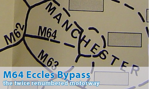
Can you show me that on a map?
When was it built?
The Eccles By-pass was completed in 1971.
What makes this a pathetic motorway?
It's not there, and never was.
Excuse me?
Well, this is a story very similar to that told over on the page dedicated to Yorkshire's M65.
Remind me.
OK, when this motorway was originally planned, all motorways were given one or two digit numbers. This restriction was lifted sometime before the completion of the first section, when it was realised that the world would not come to a sudden and premature end, and that drivers could actually read "M" followed by three digits as happily as they could cope with "A" or "B" followed by four digits...
Of course, the fact that it started life as part of the M52 is entirely co-incidental.
I see!
So, this motorway wasn't considered important enough to carry the two digit number, hadn't been opened, and had only appeared on a few maps, so it was a prime candidate for the change.
So, the M602 came into being instead, with the M601 and M606 being other planned spurs in the area.
The "more important" number was then left free for another motorway - one that was planned to be much more important to the national scheme... Of course, as it turned out, that was never completed either, meaning that the M64 number, despite being assigned to two different motorway schemes, has never actually appeared "on the ground"
Can I comment on this motorway?
Of course! Contact me and I'll put them here!
Have any other visitors commented?
Jonathan Harris:
How an earth is it that the motorways round Manchester seem to get the most re-numbering and this is the nearest motorway for me. Somewhere in the archives at home I have an old M602 black and white picture of the motorway in the early 1970s with the 1st half to Eccles built. Now it's too small for its own good with regular jams most weekday mornings and afternoons.