Where is it?
Right through the middle of Newcastle-upon-Tyne.
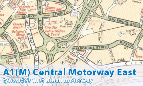
Can you show me that on a map?
What makes this a pathetic motorway?
It's not there anymore!
Excuse me?
Yep - it's no longer the A1(M).
OK - another "lost motorway" then?
Yes, that's right.
It became the A6127(M), not long after opening.
Why?
A simple enough reason - the A1 was diverted away from the city centre to use the Tyne Tunnel off to the east.
Anything else?
Nope, that's about it!
I don't suppose you've got an old map around here somewhere, do you?
Well, now that you mention it...
Can I comment on this motorway?
Of course! Contact me and I'll put them here!
Have any other visitors commented?
Nick O'Teen:
Of course, this stretch of A1(M)/A6127(M) ended up as the A167(M) that we know today.
As a boy, travelling from Morpeth to Newcastle for school on the bus every day, I saw all this happen. The road planners in Newcastle and Gateshead used to love bu&&ering about with the road numbers. I wonder if it occurred to them that sending the A1 through the Tyne Tunnel meant that every A1xx road in the Toon would be rendered out of zone?
Glenn Aylett gets all nostalgic [September 07]:
Looking at that map of the A1(M) Newcastle Central Motorway, more than likely produced in the mid seventies also makes me nostalgic for some buildings that are no longer around in Newcastle such as the BBC at 54 New Bridge St, which now belongs to an insurance company, and the old Manors station, which had nine platforms and was one of the busiest stations in the North East in the seventies.