
Comments Archive
Nic Storr:
The motorway itself actually has a sign half way up it, coming from Portsmouth, with "The Midlands" as a destination. I always thought this was rather funny, as you can get pretty much EVERYWHERE going up that motorway. I'm told its because it forms part of an E-route, but who cares about that...
Paul Evans points out:
That flyover at the start never used to be there.
It was previously just Rudmore Roundabout. The flyover was made to reduce congestion by allowing traffic for the city centre to go straight over.
This of course translates to: 'They moved the congestion a few hundred yards further up'.
They have made it worse by adding a junction from the ferry port to the M275 just after where Rudmore Roundabout connects. A junction controlled by traffic lights, though luckily not on the carriageway itself.
Robin Smith points out:
The 'No parking' sign is because returning tourists coming out of the docks, when confronted with the 3-way split (why aren't the lanes dedicated earlier?) pull over to consult a map. However, to reduce the original construction costs only a narrow hard shoulder was provided.
Incidentally, there is a hidden junction between Rudmore flyover and the 'Sails of the South', complete with slip road embankments, pedestrian underpasses, half a roundabout and reserved land for the rest of it.
Phil Reynolds has a connection between the M275 and the M6 Toll...
Are you aware that the M6 Toll has a "start of motorway regulations" sign in a strange place?
Quite early on after you have joined it going north-west from the M6, possibly where an entry from the M42 joins, or a works access, certainly before you reach junction T3, there is a "start of motorway regulations" sign alongside the main carriageway!
Now, you would think it didn't need one if it was an entry from the M42, and that it would be on the slip road if present at all. The sign comes just after the entry from a "Maintenance and emergency vehicles only" junction, I think even before the M42 is finally dealt with.
The only use it could possibly have would be to start motorway regulations for anyone who has driven there non-stop from Portsmouth Docks, using the M275 at the mad junction.
Simon Hardy:
This is a fantastic road!
A damn sight better than going on the A3 through Hillsea.
Only problem is, as said before, the roundabout just past the end of it. This is awful, especially in summer. Not so much a day in Southsea more like an hour on the front and a week to get in and out.Best thing to do would be place another motorway spur the other side of Pompey to replace the A2030. It could be the M276
Robin Smith has some more information for us:
There was a 'idea' once to make the M275 one-way inbound and the Eastern Road (A2030) one-way outbound to Portsmouth. The half-finished Winston Churchill dual carriageway was the connecting bottom part of the 'U'. Needless to say, quite a lot of good quality houses would have had to be flattened (or turned into concrete high-rise), so the 'idea' died.
As you travel west along the M27 and turn south onto the M275 you may notice a bridge over nothing to your right. Usually there are kids on motorcycles here (illegally). This bridge, and the one under the road you're on, were financed by IBM to connect the Hilsea roundabout with their UK HQ. The road would have needed a third bridge over the moat. However, the HQ site was never fully developed - about a third was built (talk now of a hotel on the rest of the site) due to changes (size mostly!) in technology.
Richard B points something out about the signage:
Is it worth mentioning the signs at the north end of the M275 which direct you to the M27 (E). As far as the maps show, there is no M27 east of this point (although building it has often been talked of).
This anomaly is more troublesome in the other direction as it once got me lost. I was travelling south down the A3 (M) from London, following someone else's directions which said leave the A3(M) onto the A27 westwards.
This tallies with the maps. However, the sign at the bottom of the A3(M) says it continues into the M27. Knowing I wanted the A27, I left the A3(M) at junction 5. This was needless, and the sign should have said A27 (or most helpfully A27 leading to M27), but definitely not M27.
I returned two years later and the error is still there
Dave Harper:
I'd like to add to the pathetic status of this road, purely for its Matrix signs. Heading Northbound there are only about 5 gantries, yet I don't think they have been replaced/upgraded since the road was built.... heck, I don't think they even been repaired.
Why are they bad?
- They seem to either be left on (for days at a time), or come on on their own accord.
- Lots of the bulbs are blown in them, so the speed limits look strange.
- Sometimes only one sign out of three (on a gantry) will be on
- I've seen one sign flashing on and off
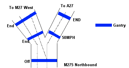
- There is only a gap of a couple of hundred meters between the gantries (about 2 seconds driving time), yet one will display "50", then the next "END". Totally clear stretch of road, no sign of any queues, accidents, bad weather...... I've attached a diagram for this one, to give a better idea.
I was hoping that they would include these in the "Communications Upgrade" that happened recently on the M27 next door, but obviously not. The M275 got neglected as the road it connects with got fancy new Text/Information Matrices. Would it have been that much more trouble to replace 15 ancient signs?
Add to the fact that in the mornings heading into the city, it isn't unusual for the enter Southbound carriageway to be jammed..... yep, the whole motorway!
Johnathan Randall agrees:
I've attached a photo showing Dave Harper's comment in action.
Here we are told to go 50, but the next gantry says end on a totally clear stretch of road.
Ashley Elford:
To add about the M275, where it starts/finishes in the north, the map shows a roundabout, however last year this roundabout was totally replaced by a traffic-light controlled crossroad junction. At 92 sets of traffic lights I believe it holds the UK record for the most number of traffic lights at one junction!
To respond to the comment about the M27(E) sign, originally the M27 was going to continue to Bedhampton, with two further junctions (14 at the A2030 and 15 where the A27 now meets the A3M). However apparently the land that was purchased for the M27 was apparently a foot too narrow for motorway regulations! This has resulted in the A27 having a four-laned dual carriageway. Despite much local campaigning, the Department Of Transport has refused to budge and make this section of the A27 and extension of the M27, which was originally planned, or even to reclassify as the A27M. This is why there is an M27(E) sign on the M275, and no-one has ever bothered to take it down.
PS: The junction that never was at Tipner - according to http://www.portsmouth.gov.uk/living/607.html, it's due to finally be completed in 2007.
Anonymous "Person X", who may or may not know about these things:
For those of you who have complained about the signals on the M275 I have good info that they WILL be replaced in the near future as part of the continuing upgrade around the M27/M3 area. IIRC the existing signals are the original NMCS1 signals (ie v.old) and so are not the most reliable on the planet. Nice shiny 9421 Indicators should be there soon. :)
As for the issue of them being on for no reason...well you'd have to speak to the operators at Netley PCO (Police Control Office) or you could try complaining to the Highways Agency on HAIL (Highways Agency Information Line). It could be that they were set due to some debris then something else happened so they were not switched off in a timely manner. It could even be a transmission failure to the signals (the transmission cables around there are almost as old as I am...) in which case the signal would stay on its last known valid setting (in this case '50' then 'End') until it re-established contact with the PCO.
Michael Harvey has a great story:
I have just stumbled across your M275 website whilst looking for details regarding the IBM HQ at North Harbour, I have a rather small claim to fame regarding the bridge that crosses over the inlet just where the Harry Pounds scrap yard was...
When I was a child we always played around the area and I watched the motorway slowly being built, they had completed the motorway (without surface) and had placed the bridge supports into the water ready for the sections that will then form the bridge. At the weekends some children (including me) would climb up the side of the motorway embankment and stand with our toes on the edge of the motorway looking down into the water (until the police would drive up and tell us to clear off).Harry Pounds had two large barges (these things were huge) one was called 'Odds' and the other was called 'Evens' and both were tied at the Alexandra Park end of his yard, inside the little inlet that forms the water boundary of Hilsea and Alexandra Park. One Sunday afternoon we thought it would be great fun to let the barges go... so we untied them and all ran off (not hard as they were only moored by a rope in a figure of eight knot)... they spent the next day hitting the supports and this caused considerable damage to the supports and set the work back by a couple of days/weeks/months and as I understand, and at quite a cost. We were traced and the police came round and gave me 'and others' a good telling off (with my parents' consent I later found out)... when the motorway was finally built we found fun in catching crabs and letting them run across the motorway (sorry but I was young and you know kids).
If anyone else remembers this incident, or the barges please get in touch...
Paul Scott has some news about the speed limit on the M275:
The M275 will be even more pathetic as the speed limits are to be reduced to mostly 60mph, but to 50mph at the northern and southern extremities; so that the hitherto unused junction at Tipner can be used at last. Work has just commenced, due for completion 10 Dec 05, includes up to 70 new road signs!
There is nothing on the DfT site to explain it, everything I've seen has been in the local papers, and on the Portsmouth City council site. I read somewhere that unusually the M275 is only the DfT's until the bridge over Tipner Lake, and from there southwards wards it is Portsmouth City Council's responsibility. I have also picked up from other internet research that the distances between successive on/off/on/off slips between the M275 merge (south of the M27) and the start of the Rudmore flyover are too short for retaining the 70mph limit, with the additional Tipner Junction in use.
There will be some horrendous lane changes northbound especially as there is effectively a 3 way split which takes the M275 to the M27E, The M27W and Paulsgrove junction. Many drivers currently seem to use the lanes up the M275 from left to right as A3/M27W/M27E as soon as they leave the Rudmore flyover! In my experience the 50 mph limit over the Rudmore flyover is to prepare for the rush hour queuing. At the northern end it makes sense to avoid traffic piling off the M27 eastbound round a tight lh slip and having to merge into fast traffic off the M275, all jockeying for the correct lane of about 6 approaching the Paulsgrove crossroads - the one with the record number of traffic lights...
Some more links, you've got the SI already
http://www.portsmouth.gov.uk/yourcouncil/5755_5809.htmThey even mention coloured patches on the motorway - will that be a first?
http://news.bbc.co.uk/1/hi/england/hampshire/4473910.stm
http://www.opsi.gov.uk/si/si2005/20051999.htm
http://www.hants.gov.uk/scrmxn/c14965.html from 1994 - explains why the extra slip roads won't be able to meet current standards."
Simon Hollett has some responses:
RE:Lack of chopsticks sign on the sliproad spur - it exists, on a gantry just inside the docks. However the docks is a restricted area so no photos can be taken :(.
The excellent junction at Tipnor is going to be built, with a 50 limit put on the M275 in preparation for this.
Also Robin Smith said that there was going to be a big one way loop around Portsmouth - I have seen plans with the A2030 shown as Motorway with an arrow (ie a we don't know) in a Roads Plan for Hampshire, dating back to the late 60s. I guess this was to fairly advanced in planning (however, Portsmouth being a borough weren't part of the plan (ditto Southampton, which has arrows down routes that were pretty much finalised)).
IMV, the M275 is the best motorway in Britain for "going exploring", with Tipnor junction, the pedestrian crossing and odd sliproad spur, and the odd overbridge over nothing at the M27 junction. In a way it's a shame that PCC is going to build the Tipnor/IKEA junction. All this in just 3 miles - surely the densest Sabristic features/mile ratio anywhere on the network.
It's also the only motorway to cross the sea (if you can count Portsmouth Harbour as "sea").
The best thing about this motorway is that it gets you away from Pompey quickly - always a good thing ;)
"Squelcho":
I was one of the poor misbegotten souls who waded daily through knee deep mud to build the bridge at Hilsea.
I'm surprised that no-one has mentioned the "incident" where one guy died, and the fact that the mid section measured up at a metre or so too short when it was dropped into place. That caused a slight delay too.
The whole project was blighted with dodgy engineering, rubbish construction techniques, and slipshod workmanship.
The Laing's section of the M27 out past Funtley and on to Southampton was made up of shrinking concrete sections that grooved under the weight of trucks and made a horrendous noise.
As disastrous motorway projects go, it's up there with the M62 trans-Pennine fiasco(subsidence, surface failures, and extreme tyre grooves on the inside lane.
Portsmouth seemed to attract engineering catastrophes like a sinister dark magnet. The beauty of the Tricorn mausoleum was effortlessly matched by the upwardly mobile dampness of Stalag Portsdown Park.
I'll bet those red prison style blocks on the Churchill dual carriageway are in a fabulous state these days. They were designed to keep the road noise from the motorway at a minimum, unless you were unfortunate enough to have to live in them.
The wind at Hilsea was usually in the 60-70mph range, which meant that when lorries arrived with shutterng boards, the instant the straps were untied, the boards would take off like lethal frisbees. One of the shoddy stores huts was completely demolished like that.
The mud was so deep that a truck would deliver about ten tons of shale every day just to keep the sloping tracks open to delivery and works traffic. I think it all came from the deep cutting at the Fareham east interchange.
Ed Fotheringham:
No need to worry about photography in the port anymore, the 'mad junction' is now clearly visible on Google Earth, you can even read the road markings!!
An anonymous contributor writes:
A few 'titbits' of additional information:
(a) when first planned, the M275 was going to terminate on the M27 at a roundabout, similar to the M271/M27 but without the northern leg. When the northern leg (to the A3/A27) was added in design, it was via a link from a second roundabout immediately to the west of the M275 terminus - maybe this was going to be the M274? Fortunately common sense prevailed and the present junction was built - the layout dictated in part by the requirement to maximise the amount of land available to IBM so they could relocate their UK HQ onto the reclaimed land. Ironically, given the cost of building the junction, it (and the M275) was only equipped with 5ft wide hard shoulders to save money (mainly on the bridges).
(b) The link road from the Ferry Port onto the M275 slip is signed as M275 from within the Port (since due to the road layout that's the only destination possible for vehicular traffic) but is not classified as 'special road' until it passes Whale Island Way. This 'special road' was not allocated a route number. So this may well be a (very - 10m or so) short section of anonymous motorway?
(c) The speed limits on the M275 are now (from south to north): 50 over the Rudmore flyover (40 on the slips), 60 from the join of the slips north to M27; 50 on the northern section to A27/A3.
Another anonymous contributor adds:
Seeing "Squlecho"s comments on the page about the blocks of flats along Mile End Road, this reminds me that the M275 was originally to have extended southwards into Portsmouth City Centre and even (although possibly by then not as motorway) into Southsea.
The blocks of flats which you see from Mile End Road are actually the backs of the flats - on the other side they have quite big windows and balconies. The motorway was going to extend down the wide centre reservation of the Mile End Road on an elevated section (similar to M4 / A4 in London) before coming to earth in Fratton. Roads along the line of this route have been upgraded but of course not to M-way standards.
A303 Paul comments:
Compare and contrast that T junction with traffic lights and pedestrian crossing on the M275 with what you find when you get to the next junction and head for the A3(M)
Yest, despite being proper D3M (or is it D4M without a traffic light in sight you are actually on the A27 because its not deemed suitable to be a motorway, apparently because the hard shoulders 6 inches too narrow or something?
Doh! - Why dont we just do away with Motorways altogether and just reclassify them all as A Roads. A50 from London to Leeds anyone?