I've not heard about this one before.
Well, that's not too surprising. Its existence has pretty much passed into legend and myth, though if you look very, very carefully in one or two places, then there are some things that remain. Even the name is today shrouded like a ghost travelling through mist.
Have you been watching 'B' movies again?
Sorry, got carried away. Again.
OK, tell me about it. Where was it meant to go?
South Bristol.
Smart alec. I suppose I asked for that.
You did, really. OK, let's be sensible for a moment at least. This motorway was designed to be the southern equivalent of the M32 - a road designed solely to get traffic into and out of the centre of Bristol quickly and efficiently. It would have run from Ashton Gate to the southwest of the city centre to M5 junction 20.
Indeed, the large Ashton Gate junction complex itself is laid out to allow for this road, and M5 junction 20 is also designed to accept connections to the Spur - which also explains why junction 20 is where it is - kind of in the middle of nowhere, serving only a minor B road and a couple of very small towns.
It was planned to be a pair with the Weston-super-Mare Spur, and if you look carefully, the M5 between the two junctions has an extra-wide central reservation to allow for widening to four lanes to account for the extra traffic between the two spurs.
I hadn't noticed that!
No comment.
So what happened to the proposal then?
Well, it was Somerset County Council that got the road on the map, as it were, in 1965, when the MoT agreed to its appearance in the County Development Plan as a motorway.
Unfortunately, it never quite made it onto the national radar, and it got canned (mostly) when Avon County Council came into being in 1974.
However, that wasn't quite the end of the story. The Long Ashton Bypass on the A370 is in fact, the washed-up remains of part of the Spur. Looking carefully, there seems to be enough space either side of the road before meeting the boundary fence. Indeed, one or two of the bridges seem to be massively over-wide, as if the motorway plans themselves were used in the construction of the bypass. The junctions are also laid out slightly oddly, in an almost offset fashion.
All in all, it's a bit odd and unusual.
So what route would it have taken?
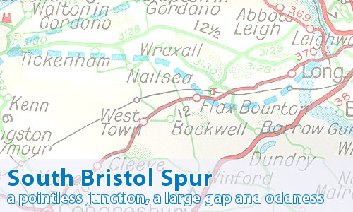
Let me show you a contemporary map, or alternatively the relevant Might Have Been Map page.
Can I comment on this motorway?
Of course! Contact me and I'll put them here!
Have any other visitors commented?
Not yet, they haven't.