What is it?
The bizarre Walton Summit Motorway.
Where is it?
Near Bamber Bridge, Lancashire. It can be found where the M61 and M65 meet, at junctions 9 and 2 respectively.
Can you show me that on a map?
When was it built?
1997
What makes this a pathetic motorway?
Well, for a start it is an unclassified motorway, without a number to call its own. It seems to be neither part of the M61, nor the M65, despite signage having existed where it claims to be both. It is unique in this regard - as although there are many short motorway spurs up and down the country, they are easily identifiable as belonging to a single motorway, and no others connect to two motorways at once.
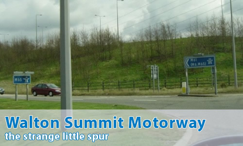
It's single carriageway, with two lanes up the hill, and one down.
Just to prove things, at the bottom end of the motorway, the start of restrictions sign "M65", but the direction flag until recently said "M61 (M65, M6)".
At the top of the hill, at the junction with the M61 and M65, there's another "M65" signpost, telling you that you've now joined the M65 around the roundabout....
It's not really called the Walton Summit Motorway, is it?
Of course not - although there are the occasional hard-of-thinking type (usually to be found on Wikipedia) who try to claim that we're making the whole thing up. Yes, clearly we are - all the photos are faked, and if you travel around the roundabout there's just this big black hole where nothing is. That's sarcasm, in case you didn't recognise it.
It's a description, you utter brainless twonks. "The Special Road under motorway regulations that runs between Tramway Lane and the roundabout at the junction between the M61 and M65 in Lancashire" is such a complete mouthful. It's a motorway, and it's in Walton Summit, so...
Can I see some photographs?
Can I comment on this motorway?
Of course! Contact me and I'll put them here!
Have any other visitors commented?
Yes, they can be found on the comments page.